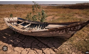
 Much of the reservoir bed is now just cracked earth
Morocco's second-largest reservoir that serves some of its major cities and has been central to farm irrigation is drying up, according to satellite images analyzed by the BBC.
Al Massira Dam, which sits around halfway between Casablanca and Marrakesh, contains just 3% of the average amount of water that was there nine years ago, figures show.
Six consecutive years of drought and climate change, which causes record temperatures that lead to more evaporation, have threatened water supplies across the North African nation and hit agriculture and the economy in general.
The satellite images that the BBC looked at were taken in the same month, March, over successive years from 2018 to 2024.
They show a stark transformation in the landscape, with areas that are normally green becoming parched and beige.
The images also "clearly depict a rapid change in the reservoir's surface area", Prof Brian Thomas, a hydrogeologist who has analyzed satellite images for Nasa, said.
The appearance of the water had also changed, he added, indicating shifts in land use and the flow of the river feeding the reservoir.
But the impact of the drought is not confined to the area around Al Massira - it stretches across the country.
Agriculture accounts for just under 90% of water consumption in Morocco, according to World Bank data from 2020, and farmers have been suffering.
Abdelmajid El Wardi cultivates cotton and wheat, as well as rearing sheep and goats, on his land to the east of Ain Aouda, near the capital, Rabat.
But he has reaped little in recent years.