Stakeholders in disaster management in Tarkwa have called for stronger household preparedness, data-driven disaster planning and district-wide disaster mapping to improve emergency response and protect vulnerable communities against floods and other disasters.
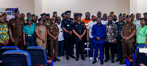
The call was made during the International Day for Disaster Risk Reduction commemoration held at UMaT in Tarkwa under the theme: “Building Resilience: Strengthening Disaster Risk Management for Sustainable Development.”
In his keynote address, the Dean of Students for UMaT, Prof. Issaka Yakubu called for stronger household preparedness, improved urban planning and the use of scientific data to reduce disaster risks.
He highlighted the growing threats posed by urban flooding, changing weather patterns and rising global temperatures, stressing that effective disaster prevention must begin at the household level.
He said homes should serve as safe havens during disasters rather than expose families to greater risks.
Prof. Yakubu also noted that low-income households often bear a disproportionate burden during disasters. Flooding can disrupt children's education, destroy livelihoods and expose families to contaminated water and other health hazards.
He therefore called for targeted support for vulnerable households, alongside measures to help affected families recover from disasters.
“Resilience starts at home. It is enabled by the choices we make together,” he said.
Prof. Yakubu emphasised the importance of geospatial tools, drone technology and Light Detection and Ranging (LiDAR) data in identifying and managing disaster risks.
He explained that these technologies could help experts map infrastructure, identify flood- and fire-prone areas, improve early warning systems and guide development away from high-risk locations.
He also called for regular drainage maintenance, adequate funding for early warning systems and the inclusion of flood risk assessments in major real estate and infrastructure projects.
According to him, effective disaster management requires authorities to use reliable data to inform planning and protect communities before emergencies occur.
Rev. Samuel Kwoffie, Health and Safety Director at AngloGold Ashanti Iduapriem Limited, called for an integrated, district-wide disaster mapping system to strengthen emergency preparedness across the Tarkwa corridor.
He said a unified disaster map would enable emergency responders to quickly identify hospitals, referral centres, police stations, fire services, safe zones and vulnerable communities.
The system would also show evacuation routes, identify blocked roads and direct responders to alternative access routes during emergencies.
“Without the map, when a call comes that there is an emergency in this location, and you cannot pinpoint that location, you will struggle to immediately know the routes that have been affected, the communities that must be contacted, and the facilities that are nearby,” Rev. Kwoffie explained.
He advocated using Geographic Information Systems (GIS) and existing technological resources to map essential facilities and disaster-prone areas across the district.
Rev. Kwoffie cautioned against relying on separate disaster management plans for individual mining operations, arguing that a coordinated system covering the wider Tarkwa corridor would provide a more effective response to emergencies affecting multiple communities.
Rev. Kwoffie also highlighted what he described as the “enclave paradox”, in which mining companies maintain strong internal safety systems while surrounding communities remain vulnerable to disasters.
“We are strong somewhere, but we are also vulnerable, and we want to move out of that kind of situation,” he said.
He called for mining companies, municipal authorities, security agencies, emergency services and community leaders to share resources, information and response plans.
He stressed that hazards do not respect corporate boundaries and that coordinated preparedness was essential to protect both mine workers and neighbouring communities.
To translate the disaster mapping proposal into action, Rev. Kwoffie outlined a 90-day roadmap for stakeholders.
The first 30 days would focus on mapping emergency facilities, safe zones and disaster-prone areas. By day 60, stakeholders should agree on their responsibilities and identify the resources required to manage different emergencies.
The final phase, covering days 61 to 90, would involve practical drills using scenarios such as severe flooding and an overturned fuel tanker. These exercises would help identify weaknesses in communication, access routes and coordination before an actual disaster occurs.
He further advocated quarterly emergency drills to strengthen cooperation and ensure that institutions and communities understand their responsibility
The Coordinator of the Disaster and Emergency Management Hub (DEM Hub) at the University of Mines and Technology (UMaT), Dr Francis Krampah, called for stronger collaboration among mining companies, security agencies, local authorities and communities to improve disaster preparedness and response in Ghana.
He said effective disaster management required collective action, regular emergency drills and investment in prevention to protect lives, property and the environment.
He cited the June 3, 2015 flood and fire disaster in Accra and the January 2022 explosion at Appiatse as reminders of the devastating impact of disasters on communities and the need for proactive measures.
According to him, mining communities such as Tarkwa face several hazards, including explosions, hazardous chemical incidents, tailings dam failures, road crashes and flooding.
“These hazards do not respect boundaries,” he said, stressing the need for mining companies, emergency response agencies and district assemblies to work together when disasters occur.

Copyright © 1994 - 2026 GhanaWeb. All rights reserved.